Showing posts with label lanark county. Show all posts

Sunday, January 3, 2021

Cleaning a vintage CCM bicycle wheel


The Canada Cycle & Motor Company (CCM) has a fascinating history. For many middle-aged Canadians today, during their childhood CCM was a respected household name for hockey equipment, including ice skates, pads, and sticks. But the company's origins date to 1899, when CCM manufactured high quality bicycles in Toronto as part of its operations with the Russell Motor Car Company. The picture below is from CCM's 1918 catalogue.


CCM's bicycle products carried through to the company's demise in 1983, although by the end they had gained a reputation as a cheap department store bike that competed with increasing low-cost imports from other markets, such as Asia. 


Although the lustre of CCM bikes has long since waned, many years ago I considered myself fortunate to have found a rear wheel from a CCM bicycle in a now-defunct antique store in Carleton Place. It's been on my to-do list for years to clean up this wheel so I could give I could display it in my office. 

According to information from this interesting site (based in nearby Perth, Ontario), it appears my wheel could date to 1908-1918. The hub is a "Hercules" armless coaster brake, one of CCM's models manufactured under license from Musselman (patent number 106391). 


The oil port in the middle of the hub is inscribed with what appears to be "JOSLUCASL2", "No 1" and "BIRMM". (I'm guessing this is a part made by Lucas Industries in Birmingham, England, which was a major centre of bicycle and motorcycle manufacturing and home of BSA.) Apparently, CCM marketed oil specifically for their Hercules coaster brake hubs in the late 1920s. Their brake grease didn't appear until the 1930s and even then the company recommended the periodic addition of a few drops of oil to preserve performance. (As a footnote, there was debate among cyclists as early as the late 1890s as to whether grease or oil was better for hubs!)


Since it's not a "New Hercules" model, it's almost certainly the original 1908 model as shown in the patent and product sheets below. 


The wooden rim was painted black and appears to lack evidence of pin striping, which was added to later, fancier models. It also lacks a metal rim strip added to reinforce later wheels, although there are two small nails and some cloth remnants near the valve hole, which probably held a cotton rim strip. As with modern rims, the valve hole is opposite the rim seam, which in this case is a glued finger joint. The wood is fine-grained and appears to be hard maple or maybe birch.


The hub and spokes are nickel-plated, the nipples are brass. 


I disassembled and cleaned the bearings and coaster brake mechanism, and straightened and chased the threads on the axle. It now works smoothly when reassembled! I also removed surface rust from the spokes and applied a conservator's microcrystalline wax to all metal parts to retard further corrosion. Varsol and linseed oil were used to clean and protect the wooden rim, as I felt this was an authentic and appropriate treatment given the probable age of the wheel. Unfortunately, there's too much corrosion to risk tightening the fragile spokes, so it won't be possible to true up the wheel. However, it holds its shape well enough as-is. 

As a bicycle enthusiast, I'm thrilled to have this wheel on display as a reminder of Canadian cycling heritage. I wonder who, a hundred years from now, may admire some of the wheels I've built?

Friday, December 25, 2020

Passages - A short ADV movie

Once again, the combined demands of work, family, and the pandemic have kept me away from posting updates, but I can assure you there's some good stuff to come. This past summer was spent riding as much as possible, exercising the Tenere and getting the suspension tuned, filming some rides, and prepping for another edition of the Ride Around Algonquin Park (RAP)--this time in a much more expanded loop up to Timmins, and with my two riding buddies from our 2018 Continental Divide Ride. More to tell about all that later.

Meanwhile, I've also been learning how to use Final Cut Pro to make movies and have just completed my first exercise which revealed a lot more learning is required. Anyway, I'm happy with the results--except for a few glitches which I had fixed but then must've accidentally undone before finalizing. 

So here it is. Enjoy!


Thursday, August 6, 2020

More mountain biking trails in Lanark County

If you're looking for new places to mountain bike in the Ottawa area, happily there are several more options today than even five years ago. However, for a region that's chock-full of beautiful forests, rocky Canadian Shield, rivers, and parks--all the raw material to become a world-class mountain biking destination--it's still somewhat incredible and disappointing there isn't more single track available to the public. Nevertheless, the Ottawa Mountain Biking Association (OMBA) has worked tirelessly with the National Capital Commission to slowly ease open some trail access in Gatineau Park. Larose Forest has seen the recent and rapid development of a well-regarded trail network for summer and winter riding. Further up the Ottawa River Valley, BORCA and others continue to improve networks at Forest Lea and along the Ottawa River near Beachburg. 

Just 30 minutes west of Ottawa in Almonte, I'm happy to report that the Mississippi Valley Trails (MVT) network I started with a small group of volunteers ten years ago is now enjoying rapid expansion and improvements for summer and winter riding as well. I've now passed over stewardship of the trail network to the Lanark County Mountain Biking Association (LCMBA) which is run by the same group of volunteers. Originally we had the trail insured and organized under the auspices of OMBA, but with the growth of local activity it made sense to form a new, separate trail management organization with its own liability insurance. 

As with any trail network, maintaining access depends on users respecting the landowners and trail rules. This spring we lost access to one section of private lands connecting the MVT section to the Mill of Kintail and Bennies Corners sections. This was unfortunate, because it meant splitting what used to be an almost 30km out-and-back ride into two separate areas with no good connection between them. However, it's understandable why the landowner closed access: a small minority of riders and dog-walkers consistently ignored requests to stay on the trail (or stay off it altogether when the entry was barricaded) and trespassed onto actively farmed lands. 

On a personal note, after ten years of grubbing out single track and wrangling land access, I need a break to deal with other life events and to spend more time actually riding. LCMBA has a good handle on taking the network to the next level. I'm thankful for LCMBA's efforts, and the growing popularity of the trails is proof that things are headed in the right direction for year-round riding. Ten years ago I knew everyone who rode; now it's rare if I run into someone I know. If you haven't checked out the LCMBA network, it's well worth a day trip. Almonte also offers many excellent options for food and drink before or after your ride. You can even jump into the river to cool off at Rock Bottom, the historic swimming hole just downstream of the town along the MVT section. 

As always, please respect the core trail rules: stay on the trail, ensure your pets are leashed, and do not leave litter or poop bags. If you're considerate of the landowners, there will be more opportunities to grow and maintain the network for many more years to come.

Saturday, June 16, 2018

Mountain biking access on the Carp Ridge


Just west of Ottawa lies the Carp Ridge formation, a strip of rugged Canadian Shield that protrudes up out of the surrounding limestone plains. Consisting largely of exposed granite worn smooth by glaciers, covered in mixed hardwood and pine forests (including some old-growth groves), and punctuated by beaver ponds and streams, it's a stunning natural area within a short drive of the Ottawa urban area.


I began exploring the ridge back in the late 80's when I visited my parents who had just moved to the village of Carp, located right on the edge of the ridge. At that time, Carp was a sleepy farming community, known chiefly as the location of the "Diefenbunker"(Canada's Cold War-era shelter for government leaders in the event of a nuclear attack) and the annual Carp Fair (one of Canada's longest-running agricultural fairs). Both are highly-recommended tourist destinations. Behind my parent's home lay many kilometers of unofficial trails into the largely undeveloped and uninhabited lands of the Carp Ridge. A large swath was owned by the City of Ottawa, who at the time seemed to have no real vision for this land except to sell it off to developers.

As the sport of mountain biking grew, so too did local demand for places to ride. The Ottawa area is, in theory, ideal for mountain biking: to the north lies the Eardley Escarpment and Gatineau Park, with hundreds of kilometers of hiking and skiing trails; on the other side of the Ottawa River lies the Carp Ridge with similar terrain in miniature, but with none of the barriers to mountain biking that the National Capital Commission (NCC) had originally imposed on Gatineau Park at the time. So, in the 1990s, unofficial trail development on the Carp Ridge began in earnest, mainly around its southern limits in an area known then as "Kanata Lakes" and now as South March Highlands (SMH).

Soon a local riding community developed around the SMH trail vision. A dedicated team of volunteers formed and systematically built a network of sustainable single track, following the IMBA model which has since been adopted by Parks Canada (among other organizations) as a gold standard for sustainable trails. The nascent Ottawa Mountain Bike Association (OMBA) took unofficial responsibility for maintaining the network, and after much negotiation with the City of Ottawa, was eventually given formal responsibility to develop and manage the SMH network, as well as some new projects. This partnership between mountain bikers and the City of Ottawa--now extended to the NCC through the development of official single track in Gatineau Park--has benefited the Ottawa area in many ways, not least by providing high quality, year-round recreational singletrack trails in beautiful nature.

As more people discover the beauty and enjoyment of the natural areas that these trails enable, demand increases for more trails. That leads us to the development of a new trail area further north on the Carp Ridge, at Thomas Dolan Parkway. Here, the land is open with swaths of exposed smooth rock; it's a much different character versus the dark, rocky forests of SMH further south. The granite resembles the slickrock of Moab, Utah--one of the world's greatest mountain biking destinations.

Thanks to the initiative and volunteer effort of mainly one person, there is now a spectacular figure-8 trail loop at Thomas Dolan. It mostly follows exposed rock outcroppings, and thanks to some clever dry-stone work, achieves a wonderful riding flow over discontinuities that is always challenging but completely doable if you commit and push your limits. It is also a perfectly enjoyable hike, and one of my favourite destinations for hiking or riding.

But now it's all at risk of being taken away. Although the Thomas Dolan trail is on city lands, a dispute between various user groups is arising about who can use the trail. The city has now officially opened a review, and there's a risk that some or all access may be lost. As an avid hiker, biker, trail builder, amateur naturalist, and--gasp!--off-road motorcycle rider myself, I'm familiar with the many sides of these land-use debates and can empathize with the views of different user groups. But, I have to say, we all need to work harder to get along. There's a lot of misinformation, misunderstanding, and blinkered self-interest going on.

One thing I would like to point out is that if not for the extensive volunteer efforts of the snowmobile clubs, ATV clubs, and mountain biking clubs, there would be very few publicly accessible recreational trails in Eastern Ontario for the community at large to enjoy. Trail-building in the challenging conditions of our region takes a huge amount of work: I know, because I lead a small group of dedicated volunteers to build and maintain a 15km public trail network for biking and hiking, as part of OMBA. An unmaintained trail can become impassible in as soon as a few weeks because of overgrowth and blow-down from storms.

While hikers represent a large portion of trail users in our region, they seem to be under-represented when it comes to helping with land access issues and developing sustainable shared-use trails. Yet, I can't help but observe that hikers are over-represented as leavers of dog poop bags and other garbage (coffee cups, beer cans, etc.) on the trails I manage. Nevertheless, whether we are bikers, hikers, snowmobilers, or ATVers, we all have much more in common with each other than initial impressions may suggest. Sure, there are a few bad representatives in every group. But if we work together more, and look harder for common ground and shared interests, we can build much-wanted trails that allow everyone to enjoy our lands together, in sustainable and low-impact ways.

Regardless of your preferred outdoor activity, if you want to continue to enjoy access to your local trails, please support one of the local clubs that build and manage these trails. Even if you can't volunteer your time, your membership fee will help to pay for the equipment and insurance needed to keep the trails open.

Tuesday, April 10, 2018

When thoughts turn to spring...

Trails are finally starting to thaw and dry out here in the frozen north, and some green shoots are even poking out of the ground in a few places. Soon it will be that magical two weeks between mud and bugs, when summer riding season starts again. 


Friday, August 18, 2017

Exploration: Round Algonquin Park 2017 via TCAT and Cobalt - Part 1

In 2016 I completed a solo, 1200km, three-day dualsport route clockwise around Algonquin Park (RAP) starting in Almonte, just west of Ottawa. It was hot, dusty, and challenging--particularly on the first day through the Bancroft area south of the Park, where there are long sections of rutted, technical trail far from support--but lots of fun. Most of the route followed the TCAT up to North Bay, then picked up on the Algonquin Dualsport Route described in the Backcountry Routes guide.

This summer, I repeated the route and doubled it by exploring further along the TCAT past Sudbury, looping over to the fantastic historic town of Cobalt at Lake Temiskaming and rejoining my original route at Mattawa. The theme this time was to spend more time exploring the many ghost towns and old mines along the way, and to get a better sense of the local history. The map below shows my planned route, but--and as you'll see later--some of it proved impassable and I had to go around.


Altogether this year's ride took six long days, four of which consisted of torrential downpours, soaked clothing, and mud. Lots of alone-time in the helmet, absorbing the vast expanse of our beautiful and rugged province, talking to myself, and contemplating the merits of maybe getting a slightly larger motorcycle for future adventures. But my bulletproof WR250R was once again a total champ and got me through unscathed.

Unfortunately, whereas last year my phone died after day one and I could no longer take pictures, this year it was the turn of my new Garmin 64st to crap out, which happened on the last day with the result that I lost all my trip data. This is my third such Garmin in just over year. The previous 64st (which was replaced under warranty) and before that a 60cs all died on their own for random reasons. Without a reliable guide to the turnoffs, on the last day I was forced to abandon the interesting backcountry trails taking me home to Almonte from Mattawa that I had followed last year.

Overall it was a fantastic ride with a good mix of technical trails, stunning scenery, historic detours, and a total mining geek-fest in Cobalt. Highly recommended for small- to mid-sized adventure bikes with at least 250km range and ideally 350km range (in my case, achieved with a 12L tank and 4L RotoPax). You should also spring for a trail pass from TheTrail.ca, since the funds help the Eastern Ontario Trail Association access and maintain these beautiful locations to ride.

My bike set-up and travel gear was essentially the same as last year: lightweight, camping-oriented, and with tools, spare tubes, and minimal food and clothing. However, whereas last year I rode on full knobbies, this year I rode on Mitas E-09 50/50 tires in arguably worse trail conditions, yet they performed very well. Given the long stretches of unavoidable pavement this time around, I actually preferred not being on knobbies. Another key change was having my suspension re-valved last fall, and installing a stiffer shock spring. This made all the difference in the sand, whoops, and ruts--no major control issues at all despite being a loaded bike.


My route out of Almonte followed my local trail sauce before connecting with the TCAT. Lots of dirt roads with some roller-coasters thrown in.


The section north of Dalhousie Lake is rugged and beautiful - well worth a day ride from the Ottawa area. 


Here's typical evidence that today's hamlets were much more vibrant (and populous) communities a hundred years ago:


On Buckshot Lake Rd., my route was supposed to turn west onto Brooks Lake Rd. as dirt way through to Highway 41, but this proved to be a dead-end not far past a lonely homesteader's cabin. The only sign of life on this road was, improbably, an immaculate new Mercedes SUV that was crawling over the boulders and steep hills behind me, presumably to access the lake at the dead-end. Yee-haw. Last year I tried a different route through this section, but I got stumped then too. Many years ago I did a mountain bike ride through this area as part of a 24-hour adventure race, but I have yet to rediscover that route which wound over to the top of Mazinaw Lake.


No choice but to turn back to Buckshot Rd. and follow it around through Vennachar to Ferguson Corners. From there, the route on Smith Lake Road was a long, beautiful ride on sandy dirt with a few rough and wet sections and vestiges of pioneer cabins now as hunt camps and shelters. This is a highly recommended section to ride on almost any bike, also within reach of a day-trip from Ottawa.


One of the notable stops along this remote section was the ghost town of the Bessemer Iron Mine (1899-1914), which required a northern detour to reach a former rail bed to the mine. This is well worth a look although the mine site proper is now closed off on private property. A great video of the mine site on the private property is available here

Here's the right turn onto the former rail bed to Bessemer: 


Before long, you reach the site where a town of about 300 miners and their families once toiled for a better future. Just to the left of where my bike is parked you can see where the old rail bed runs into a rock cut in the woods, and from there to the mine head as shown in an old photo below. 


This same location on the road is actually the former "downtown" area of the community, with boarding houses, shops, post office, etc. On the  right (south) side of the road, hidden in the trees, is an intriguing hole blasted out of the rock, with what appears to have been stonework around the top. A book by Dave Hanes about the mine's history (details below) suggests this feature was built as a cold storage to serve a large log boarding house, the east end of which was located about 40 feet west of the hole.


Just east the blasted hole and on the same side of the road is a large and impressive stone foundation. Hanes's book records an interview with one of the local old-timers who worked at the mine, who said the old log boarding house had no foundation and was built right on the ground (indeed, I saw was no obvious evidence of a foundation beside the hole/root cellar). This stone foundation was built for a hotel and never finished: "never had a board on it" said the old-timer. There are apparently some other foundations in the general area, but I didn't have much time to explore. 


This small hunting cottage was, I think, originally the company store for the mine.


A small stream drains from Mullet Lake (seen below) into Little Mullet Lake (where most of the mining occurred). Here's where the stream crosses under a culvert in the trail. A sawmill was located here. A diver who explored the lake bottom near this site found the remains of a log sleigh and team of horses that presumably fell through the ice back when the mine was running.


According to an old site map, the Bessemer school house was located on the left shoreline of Little Mullet Lake as seen in this picture from the road/railbed. 


For more detailed information about the history of the Bessemer Mine, Dave Hanes's book "Iron Mining at Bessemer 1899-1914, The Hand of Father Time" (ISBN 0-88954-424-7) is an excellent resource. Hanes conducted extensive research at the site and interviewed key old-timers in the area--the stories are entertaining and provide a fascinating perspective on a era of early European settlement in Ontario that has all but disappeared into the bush. You can order the book from Darlene at the bookstore in Cobalt (more on that later). Here's a view of the main mine workings, I believe from a perspective near the end of the overgrown rail line through the rock cut shown in a picture above. 


The overgrowth and bugs proved too obstinate for me to explore here further, so I carried on with my main adventure and headed on to Bancroft. 

After Bancroft comes one of the most challenging sections of trail on the whole route: Pencil Lake Road. It's a heavily rutted, rocky ATV/Jeep trail that nevertheless is a riding highlight of the whole route. Last year I followed this road to its end near Irondale (another ghost town), but there was one particularly rough section with a deep swamp that required bypassing via a steep climb and descent over a large knoll of bedrock. Given the torrential rains this year, my slower progress overall, and the likelihood of much more standing water on the section of the trail, I decided to avoid the risk in favour of investigating an alternate route. The TCAT showed a detour from Pencil Lake Rd. north onto Hadlington Rd., which in theory should've avoided the need to ride through Pencil Lake Rd's long sections of standing water. Indeed, the bypass started out just fine:
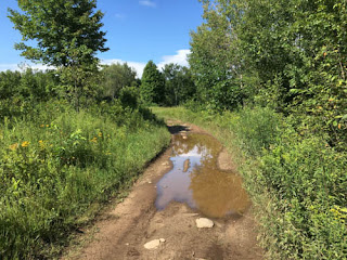

Then it quickly devolved into hellish mud pits which I was barely able to ride with my 50/50 tires, despite a relatively light bike. Fortunately I had thought to bring a handsaw with me, so I was able to remove some strategic branches and pass beside several of these holes. However, I got stuck in a few holes that were slimy, sucky, deep mud (2 feet deep in some places). It was pretty miserable trying to pull myself out while of course a storm arose and raged around me. I absolutely do not recommend this alternate route for larger bikes. It was one hole after another for a few kilometers, few of which offered a way around that could be navigated with bags on. Definitely one of the worst (or, should I say "character-building") sections on the whole trip. In retrospect I would take Pencil Lake Rd. all the way again, because if memory serves me, much of the trail had a rocky base and lacked this type of silty mud.


Suwan's Thai Restaurant in Minden made a welcome and tasty (but slow) dinner stop before heading north towards my first camp near Huntsville. The owner and his Thai wife split their time between Minden and Thailand, and have collected all manner of ephemera which is displayed (and for sale) in their popular restaurant. 


Two days before, a tornado had ripped through the Baysville area north of here. The trails in that section are active forestry roads and they were saturated, rutted, washed out, and covered in storm debris. No pictures; I was tired, wet, and scrambling to get through in one piece as dusk arrived. After a long paved section I finally reached my first camp at our family's cabin on Lake Solitaire.

Here's a view of the cabin, which my parents bought from a close family friend whose father had built (and stocked) the cabin around 1920. No electricity, no water. Still rustic like the pioneer cabins back then.


Part 2 covers my progress further along the TCAT through the forests, ghost towns, and sandy glacial till that stretch north of Huntsville well up past Sudbury. New challenges, new things to see, and finally some pictures of the route since I wasn't able to get any last year!  

Tuesday, September 6, 2016

Dualsport on your doorstep: Lost communities near Corkery Road

Halfway between the 417 and Almonte, just west of Ottawa on March Road, lies the Corkery Ridge, an intriguing bit of history, and forgotten communities.

Cresting the ridge reveals a spectacular view west: a long, shallow valley runs north-south, with exposed limestone on the slopes, swampy ground at the bottom where Peter Robinson Road and then Upper Dwyer Hill Road cross March Road,  scrubby vegetation eking out an existence among the rocks and swamps. A few pioneer log homes dot the area, as well as some magnificent Eastern White pines that are possibly remnants of the original old growth forest.

At the top of the ridge lies Corkery Rd running south, and just past the corner is St. Michaels Catholic Church--another remnant of the pioneer days and the mostly Irish immigrants that settled this little pocket of Huntley Township in Carleton County.

On the far side of the valley lies a large quarry run by the Cavanagh family. Behind the quarry and up on the far ridge lies Burnt Lands Provincial park, an alvar that is remarkably rare in the world and home to rare plant and animal species found nowhere else.

Most of this view can be taken in with one quick glance. It’s a pretty but unremarkable view of rural life today: Some old farms, some newer ones, a few McMansions placed imperiously. I’ve seen this view thousands of time on my daily commute into Ottawa. But I always wondered, who was Peter Robinson and what lies down the unopened section of road between March Road and Old Almonte Road, that bears his name?

Here’s the view of Peter Robinson Road as seen from the Old Almonte Road. 


Since it’s in a swamp, it’s usually filled with water. However, this year’s dry summer dried things up enough to convince me to take a look. 


Turns out there’s a solid layer of rock beneath the dirt, making it easy to ride. Just a few puddles to run through.


After a couple hundred metres, the swamp gives way to a gentle rise that turns into an island of sorts, surrounded by swamp in all directions. It’s a beautiful location: quiet, breezy, completely remote and invisible from the surrounding area.


So I’m surprised to note what appears to be an old building up on the rise. Sure enough, it appears to have been a fine log home with high ceilings, large windows, a rubble foundation, and at least two doors. The roof has long since caved in, but inside are the remains of plaster wall coverings. This was no shanty – it was clearly a loved home.


There’s too much overgrowth to get much of a closer look. 


A few dozen metres away lay the remains of a significant barn structure, and possibly the original shanty that the settlers built until they could erect a more permanent home.


There was also recent evidence of visitors: shotgun garbage scattered on the ground. Otherwise the site appeared to have been abandoned for many decades, probably not even used as a hunt camp in at least 50 years.


The old road continued past the farm, but soon became impassable swamp, so I didn’t risk it and turned back.

Now I was intrigued: Who lived here? What’s the connection with Peter Robinson? What’s the story behind this forgotten pioneer home surrounded by swamp and clearly isolated from any recognizable community?

Some online research revealed part of the story and a few more surprises. Peter Robinson was well known by 1834 as someone who arranged for many shiploads of poor families to leave Ireland and settle in Huntley Township. He worked tirelessly to give them an opportunity for a better life and seems to have been widely respected for these efforts. Many common family names around Almonte and Corkery today, including the Cavanaghs of quarrying fame, can trace their roots back to Peter Robinsons ships.

Consulting a map of Huntley Township from 1879 revealed that the land where the old log house lay belonged to James Carter. It even showed a house in the same location as the ruins. More sleuthing uncovered obituaries in the Almonte Gazette for Elizabeth Carter (nee Kelly) and her husband, JamesCarter, who was born 1824 in Tyrone, Ireland, and died in 1894 in Huntley Township. The family grave is just up the hill at St. Michael's. 


James arrived in Canada in 1845. Although there were a few James Carters on the passenger lists of the Peter Robinson ships, it's seems clear he wasn’t one of them. He originally settled in Ramsay Township (home to Almonte) and then later moved to Huntley Township. There are only three lots registered to a James Carter in Huntley, and they are adjacent to the one with the ruins. Clearly this was the homestead of James and Elizabeth Carter, and their ten children--one of whom, Patrick, continued to live at the homestead.  

I’m guessing the home was built after the great fire of 1870 which swept through the area from Almonte to Ottawa and destroyed pretty much everything in its path. And it was obviously built before 1879, the date of the map. It was probably built between 1871-1878.

Here's the satellite view of the site:


Peter Robinson Road is visible along the treeline at top right; the house is the smaller square rectangle at lower right. The faint white lines indicate the unopened road allowances which are still registered with the Province of Ontario. 

How did James and his family get to and from the home? Where did they connect with their community? The swamp route along Peter Robinson Road was probably not viable for most of the year. I’m guessing there’s a higher path that leads towards Upper Dwyer Hill Road. Remarkably, there were several options for nearby community, although nothing remains today.

The old map shows that the intersection of Corkery Rd and Old Almonte Rd (where today stands a modern home) used to be called West Huntley, where there was a store and post office. These buildings were destroyed in the 1870 fire and presumably that was the end of West Huntley.

On Old Almonte Rd near the intersection with Upper Dwyer Hill Rd was another community called Clandeboye, also home to a post office. Nothing remains today except a few modern homes. The former Herb Garden across the road was probably part of the hamlet.

Most intriguing is that at St. Michael’s Church on the crest of March Rd, the original path of Corkery Rd continued across March Rd and along the slope where today there’s a rural subdivision. This road descended the ridge at a lower slope and met up with Carroll Road where it crosses Peter Robinson Road. Many years ago, before the subdivision on the ridge was built, I met the owners of the farm at this intersection and they invited me to mountain bike up the ridge to the forest beyond. The satellite image of the ridge shows signs of a vestigial road in this location. Little did I know, the route I’d cycled from Almonte through the Burnt Lands, down the old Carroll Road allowance, and up the ridge was in fact one of the original routes into Almonte before March Road was opened through the steep ridge beside Cavanagh’s quarry.

Also intriguing is that along the Carroll Road where it rises into the Burnt Lands was another hamlet called Powell, where there was a hotel and post office. Today it’s just bush but now I’m really curious to see if any signs of the former buildings remain.

All of these locations are marked in orange on the following map. The blue rectangles indicate the approximate views of the satellite images. 


Here's the vestigial road down Corkery ridge. It's barely visible as a diagonal depression running from top right down to the farm house at bottom left:


Here's the probably location of the Powell hotel and post office on Carroll Rd:


James Carter and his family lived in what was probably a more bustling farming community than today’s sleepy rural farmland would suggest. However, the lure of fertile land drew many of the Huntley pioneers west, and those who remained would’ve faced soul-crushing work rebuilding their lives after the total destruction of the region by the 1870 fire.

Here's a class photo (dated maybe 1924?) from the old school #6 that used to be located near the present-day firehall up on Old Almonte Road past Corkery Road. The indicated Carters are not children of James and Elizabeth, but may be grandchildren or great-grandchildren descended from Patrick, who continued to live in the home. If so, then the old farm may have been inhabited in 1924.