Showing posts with label history. Show all posts

Sunday, January 3, 2021

Cleaning a vintage CCM bicycle wheel


The Canada Cycle & Motor Company (CCM) has a fascinating history. For many middle-aged Canadians today, during their childhood CCM was a respected household name for hockey equipment, including ice skates, pads, and sticks. But the company's origins date to 1899, when CCM manufactured high quality bicycles in Toronto as part of its operations with the Russell Motor Car Company. The picture below is from CCM's 1918 catalogue.


CCM's bicycle products carried through to the company's demise in 1983, although by the end they had gained a reputation as a cheap department store bike that competed with increasing low-cost imports from other markets, such as Asia. 


Although the lustre of CCM bikes has long since waned, many years ago I considered myself fortunate to have found a rear wheel from a CCM bicycle in a now-defunct antique store in Carleton Place. It's been on my to-do list for years to clean up this wheel so I could give I could display it in my office. 

According to information from this interesting site (based in nearby Perth, Ontario), it appears my wheel could date to 1908-1918. The hub is a "Hercules" armless coaster brake, one of CCM's models manufactured under license from Musselman (patent number 106391). 


The oil port in the middle of the hub is inscribed with what appears to be "JOSLUCASL2", "No 1" and "BIRMM". (I'm guessing this is a part made by Lucas Industries in Birmingham, England, which was a major centre of bicycle and motorcycle manufacturing and home of BSA.) Apparently, CCM marketed oil specifically for their Hercules coaster brake hubs in the late 1920s. Their brake grease didn't appear until the 1930s and even then the company recommended the periodic addition of a few drops of oil to preserve performance. (As a footnote, there was debate among cyclists as early as the late 1890s as to whether grease or oil was better for hubs!)


Since it's not a "New Hercules" model, it's almost certainly the original 1908 model as shown in the patent and product sheets below. 


The wooden rim was painted black and appears to lack evidence of pin striping, which was added to later, fancier models. It also lacks a metal rim strip added to reinforce later wheels, although there are two small nails and some cloth remnants near the valve hole, which probably held a cotton rim strip. As with modern rims, the valve hole is opposite the rim seam, which in this case is a glued finger joint. The wood is fine-grained and appears to be hard maple or maybe birch.


The hub and spokes are nickel-plated, the nipples are brass. 


I disassembled and cleaned the bearings and coaster brake mechanism, and straightened and chased the threads on the axle. It now works smoothly when reassembled! I also removed surface rust from the spokes and applied a conservator's microcrystalline wax to all metal parts to retard further corrosion. Varsol and linseed oil were used to clean and protect the wooden rim, as I felt this was an authentic and appropriate treatment given the probable age of the wheel. Unfortunately, there's too much corrosion to risk tightening the fragile spokes, so it won't be possible to true up the wheel. However, it holds its shape well enough as-is. 

As a bicycle enthusiast, I'm thrilled to have this wheel on display as a reminder of Canadian cycling heritage. I wonder who, a hundred years from now, may admire some of the wheels I've built?

Friday, April 19, 2019

Continental Divide ride 2018 - Part 10

Part 9

Leaving Buena Vista, Colorado, our intended route was to head up to Cottonwood Pass where we'd regain the Colorado BDR on the crest of the Divide and follow it south. But we discovered the road was closed throughout 2018 to allow for a major renovation of the pavement. Too bad, because one of my personal goals for the trip was to soak in the Cottonwood hot springs near the start of the ascent, which I'd last visited with a friend on a mountain biking trip back in 2007:


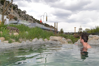
However, the other guys weren't keen on the hot springs, and since we had to find another route, it was out of our way. While I was a little bummed by this, there was still lots to discover and the hardest parts of our trip (with all their uncertainties and how they'd affect our schedule) still lay before us. Tincup Pass just to the south looked like a convenient alternative route back to the BDR, although we'd heard it was one of the more technical options and could be a significant challenge on loaded ADV bikes. Despite some trepidation from the other guys (see, that's where pre-relaxation in a hot spring can help!), we were all pretty excited to give it a shot.

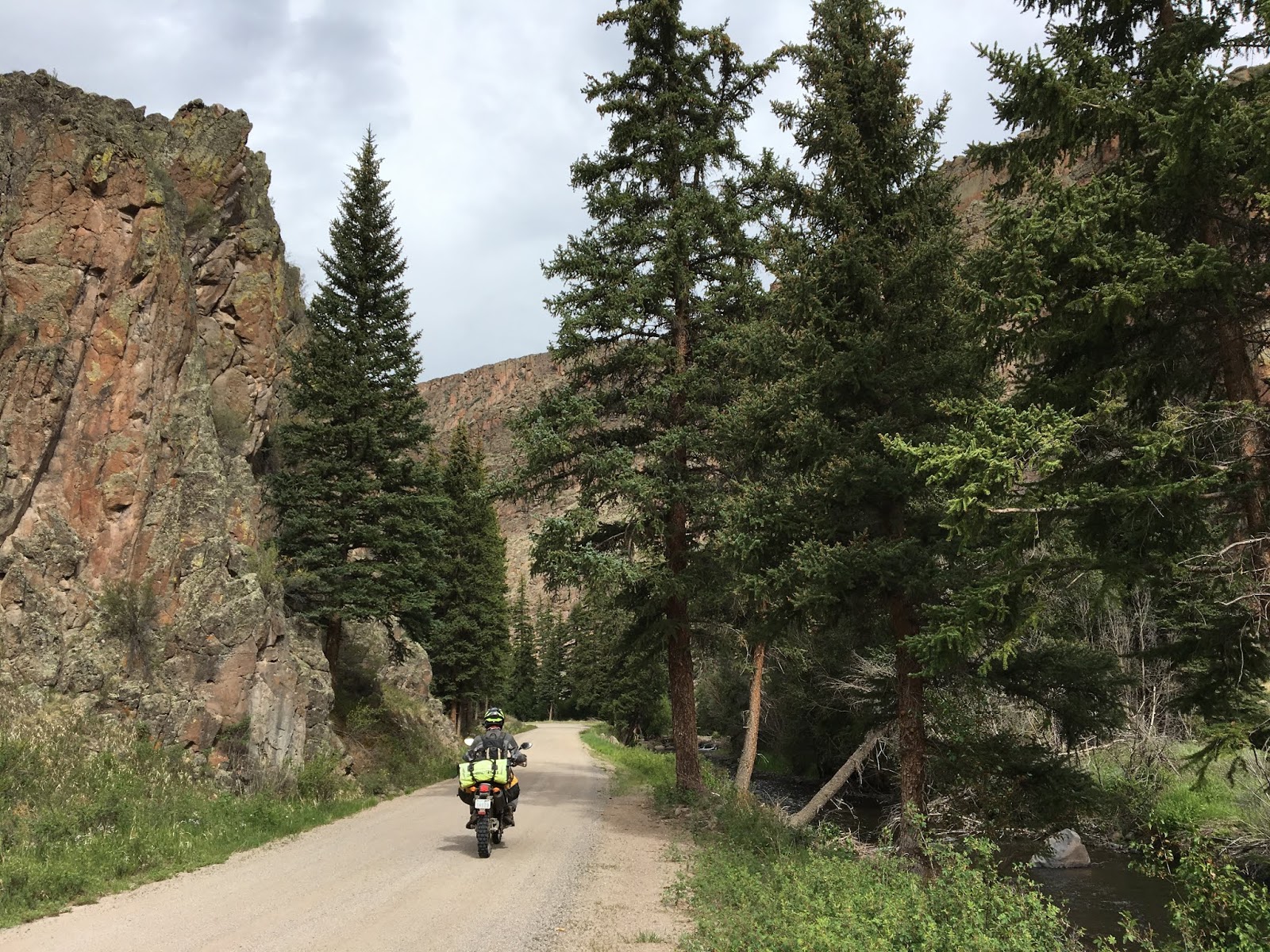
The approach to Tincup up Chalk Creek gulch passed by Mt. Princeton and the aptly named Silver Cliffs, which were brilliantly illuminated by morning sun.


Eventually we reached the historic mining town of St. Elmo.


While there didn't seem to be much open to visitors when we passed through, the town now serves as a major jumping-off point for OHV tours and was buzzing with squadrons of Jeeps, side-by-sides, and the occasional dirt bike arriving and lining up for departure. We were the only ADV riders in sight. Had there been no crowd, we might've looked around a bit. Instead, we decided to head straight for the top to avoid worsening congestion.

Since the road over the pass is designated a county road, you don't need an OHV permit to travel it so as long as you stay on the main track. But don't be fooled by the county road status: this pass proved to be one of the most technical sections of the whole trip. Jeff had already worked up some serious anxiety after watching a number of Jeep videos the night before, whereas Pete was his usual cheerful British understated self, Buddha-like in his philosophical reaction to danger.

It was indeed hard work, and I wasn't able to grab photos of the ascent since there was no good opportunity to stop. Be assured the track was narrow, steep, lined with dense bush, covered in loose softball- and head-sized boulders, washed-out, rutted, and overrun with OHV traffic that couldn't travel very fast and raised choking dust. Couple with the elevation gain, both my and my bike's engine struggled to breathe and stay cool.

Maintaining forward momentum was key to staying upright, so a lot of my riding was in gears 1-3 to handle the grade and not stall out. Too slow, and the suspension would just follow the bumps instead of compressing, causing you to get stuck. Too fast, and you'd jackhammer the obstacles too hard, get air, and lose control. You had to trust that your bike would work and use the gas. The magic speed for me was about 2-3 times as fast as the OHVs, so I was able to fly past them on the few occasions where there was room, and when we could see each other through the clouds of dust. There were few places to stop in the forest on the way up, so each of us picked our own way on our own time, using our helmet comms to call out obstacles and strategies and novel curses.

Had the trail been wet or muddy, it might very well have been too hard for us to ride with our loads. There was lots of evidence of prior mud and deep puddles, but amazingly it was mostly dry for us and therefore reasonably grippy.


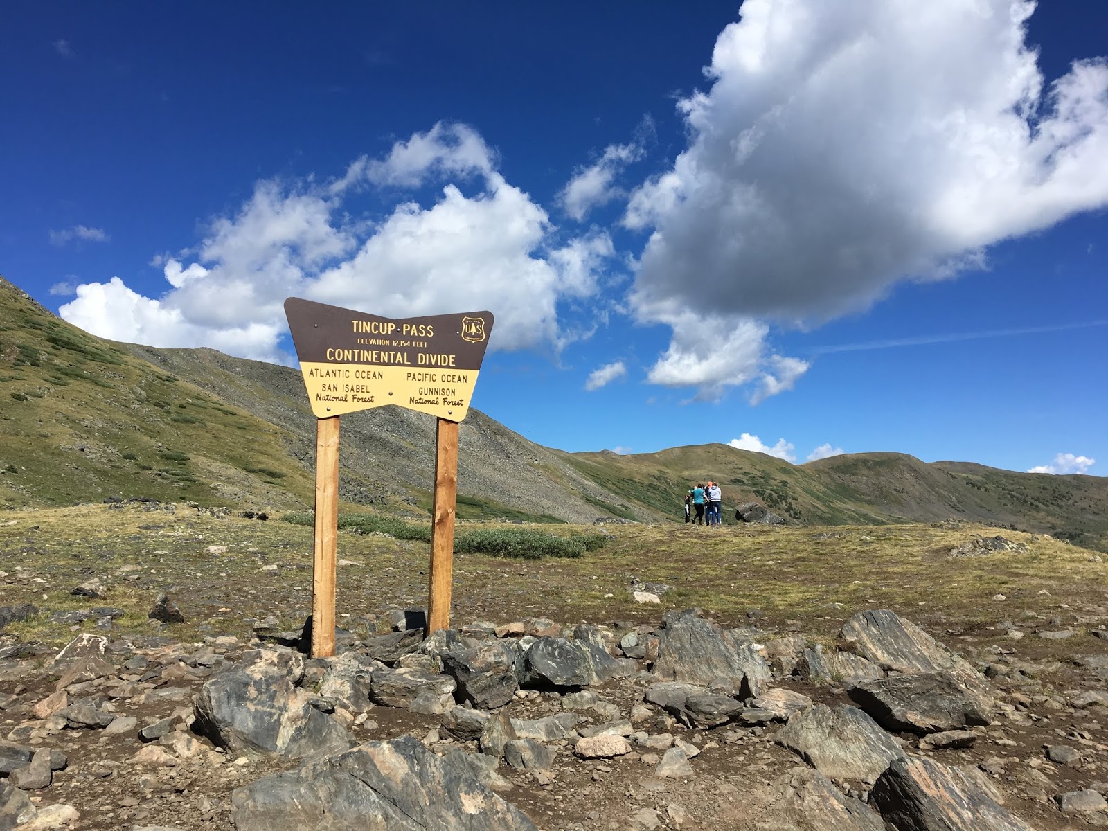
We arrived at the pass (12,154') all sweaty and pumped out, glad to have the traffic jams behind us.


The descent proved harder: first, a greasy series of rock steps among loose stones. I went first to recon a line, and then together we coaxed and spotted each other through, each taking different lines with a couple of dropped bikes along the way. It would've been significantly easier without our loads, which added unwanted inertia to delicate maneuvers and sapped throttle response--especially at the high elevation. 


The steps were followed by a white-knuckle ski-ride down a relentless grade with a ball-bearing surface. Braking was all but useless with our loaded bikes, so again we had to find a speed that was fast enough to let the suspension do its thing, but not so fast that you'd run away and hit something too hard--which included significant traffic coming uphill towards us. It took all our concentration to ride, because often the best line was blocked by an oncoming Jeep or ATV and you'd find yourself bouncing through the worst of the loose stuff. Most of this section would've been a real challenge on a big ADV bike and I wouldn't recommend it unless you've got long legs (or a low seat), have full knobbies, and are very comfortable riding technical trails.


Today there's little to see in the historic mining community of Tincup, although it's a popular stop for OHVers and there's a small seasonal population.


Tincup put us back on the Colorado BDR, so we continued south along the crest of a range with wide vistas in all directions. This view is looking towards the north, where in the distance we would've reached the same road via Cottonwood Pass. 


Few vehicles, and no services. You're pretty much on your own in these parts. Didn't see any other motorbikes. The whole area is dotted with the countless remains of old mines and ghost towns. 


More desolate dirt road led us through Pitkin, Cumberland Pass, and Wuanita Pass, descending from the sharp peaks through forrest and into high plains terrain. We began to see a few ADV riders passing us on their way north, but remarkably few other signs of civilization as the forest gave way to open ranch land. As we descended, it got hot and windy--typical in the mountains as the sun's energy builds into afternoon storms. 

At a stop along the way we discovered that Pete had lost his RotoPax. The hardware had vibrated loose, and both the can and entire mount had managed to slip out from under his strapped-on top bag and ended up as valuable trail booty for someone else. After reviewing photos, we figured it probably happened somewhere on Tincup Pass, and simply wasn't obvious because his bag normally obscured the RotoPax anyway. Nevertheless, we were now in a remote area and Pete was short of fuel. We decided to deviate from our route to nearby Gunnison for grub and gas. Last time I was here in 2007 it was pouring rain and deserted, and I didn't get to ride the local trails. Now the town seemed much more bustling, and downtown we found a good brew pub with friendly staff. 

With storms threatening and Jeff particularly worn out from the day's technical riding, we left Gunnison to pick up the BDR again and look for camping. The entire area was open range with no easily accessible forest, so we were concerned about finding a spot where we wouldn't be exposed to either storms or gun-toting ranchers. Miraculously--and almost at our wits end for the day, a recon down a dirt track revealed a hidden reservoir with campsites, an outhouse, and a lot of 9mm brass scattered around. A dodgy trickle of water leading into the reservoir proved barely adequate for cooking. The natural bowl of the site provided both shelter from the wind and amplified acoustics, allowing the smallest squeak from birds or beasts to be amplified somewhat alarmingly in the middle of the night, when we heard splashing in the little stream beside our tents. 


Nothing like a little Bourbon to take the edge off! Should've gotten more of this.  


None of us had a great sleep that night. The next morning, and low on water, we ate handfuls of trail mix and pushed on towards the highest passes of the trip. By this stage we were each pretty much lost in our own thoughts, isolated in our helmets somewhat by the unreliable and garbled communications of our Senas, which were often drowned our by noise from the relentless wind tearing across the open range.

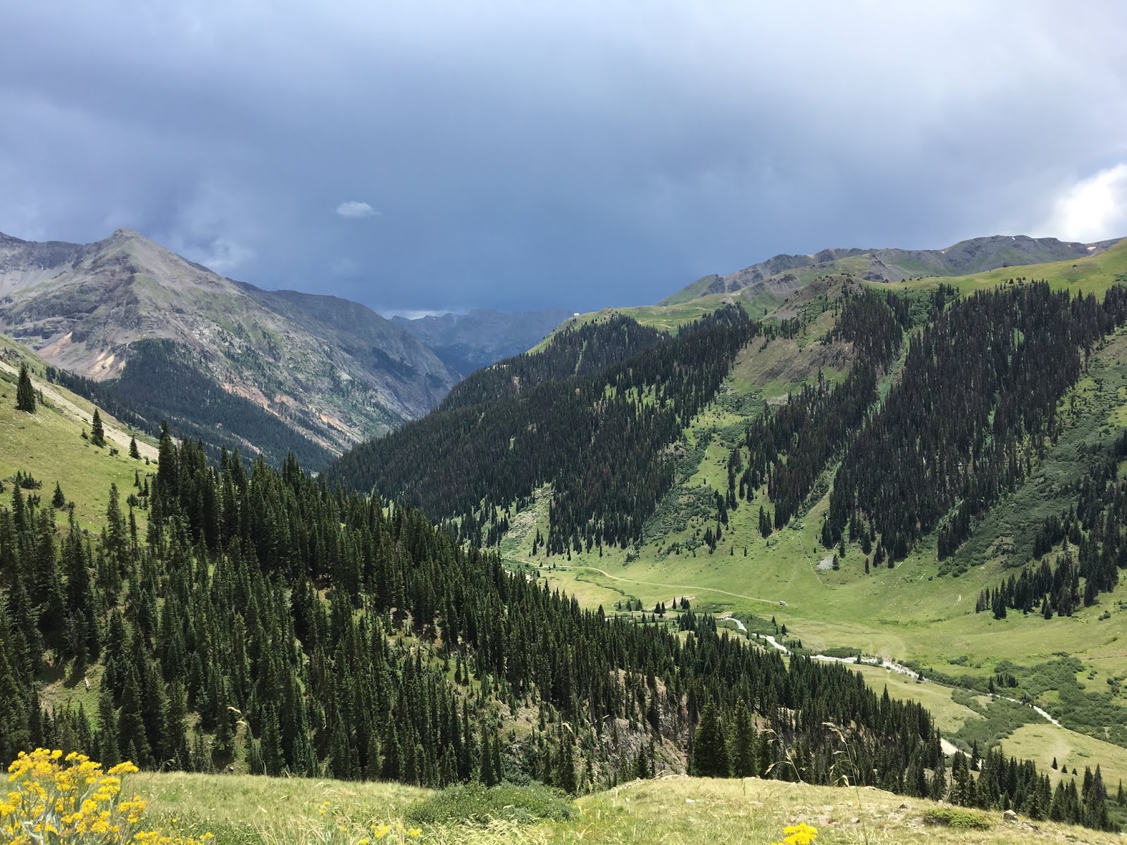
Soon the dry, almost desert-like country rose into the fragrant forests of Los Pinos Pass. The dirt track descended into canyons and the emerging San Juan Range.  


Ahead lay the highest passes of the trip, but first we needed to cross an extraordinary geological feature.


According to the sign at a visitor's pullout:
About 850 years ago, thousands of tons of water-saturated, earthen material broke away from Mesa Seco and slid nearly four miles into the valley below. The Slumgullion Earthflow dammed the Lake Fork of the Gunnison River and formed Lake San Cristobal - the second largest natural lake in Colorado. 
About 350 years ago, another portion of Mesa Seco began to slowly ooze down the hillside. Riding above the older slide, this flow covered about 2.5 miles of the older flow. Geologists estimate that it is still moving downhill approximately twenty feet per year. 
There were many signs of the slide, including large stands of trees tilted at an unnatural downhill angle. A freshly paved highway carved down through the slide, affording some fun cornering after days on slippery dirt.

The frontier town of Lake City made a good brunch stop with free wifi, and there's a good general store with freeze-dried food, nuts, jerky and other ADV essentials. Some interesting old stone buildings in town and again, platoons of ATVs all lining up for day trips over the high passes next on our own agenda. The police were in full action pulling over speeders in ATVs, so it's important to ride carefully here.


Replenished and full of eggs and sausage, we followed the traffic towards Cinnamon Pass. While nowhere near as technical as Tincup Pass, at 12,640' it was one of the highest on our trip and it followed a steep route that required your attention--not least because of all the other trail users and the effects of elevation. The scenery was literally breathtaking, and I could ride this over and over again.


Although it was a struggle for our 250s, we made it over the pass and dropped down into the mining ghost town of Animas Forks at 11,200'. A National Historic site, it's famous today for the remarkable state of preservation of its buildings, which you can walk through. The site receives more than 100,000 visitors per year, and we could believe that given the steady stream of Jeeps and side-by-sides crawling up and down the mountain roads to this location.


Here's what the town looked like circa 1906. Incredibly, there was once a railway to this location:


And today, from a similar vantage point of one of the former mine sites. The road to the right leads up to Engineers Pass, another extraordinary feat of willpower over nature. This pass remains on my bucket list but it's more technical than most and probably requires an OHV permit and more horsepower than my 250 can muster.


The two-story building with the bay window on the right of the above photo is the William Duncan House, built in 1879. Here's a view from inside:


At a home next door was this indoor latrine, below. One winter, the town received 25 feet of snow and residents had to tunnel between buildings. Having indoor "plumbing" would've been a necessity compared to an outhouse. I recall distinctly the outhouses I lived with as a boy in Australia, and certainly wouldn't want to have to trudge out to one in the dead of winter at these elevations.


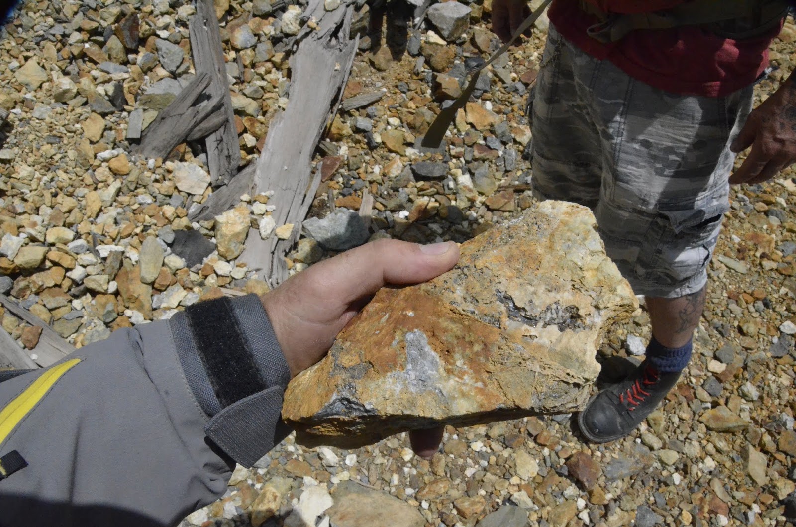
Met a guy rock-picking a tailings pile, and he showed me this excellent sample of silver ore-bearing rock.


By now the afternoon storms were rumbling in, and we were concerned about getting caught on an exposed ridge where lightning strikes could pose a very real risk. We opted to get down to lower ground quickly, and decide next steps based on what the weather did.


Not far south of Animas Forks is the ghost town of Eureka. While we didn't pass through there on our trip, I recently on a a Reddit thread the following photo from 1900 that's been expertly colorized by Sanna Dullaway. It really helps show the historic appearance of the region.


The same view today, at the same location, can be seen here on Google Street view (photograph by Seth Thomas).

With the storms seeming to head in the opposite direction, we decided to make a sprint for California Pass, the highest of the trip at 12,960'.

Part 11

Saturday, August 19, 2017

Exploration: Round Algonquin Park 2017 via TCAT and Cobalt - Part 2

Click here for Part 1.

One good thing about rain when adventure riding is it tends to firm up loose surfaces -- especially sand -- making them a lot easier to ride on with a loaded motorcycle. So the previous day's rain was actually welcomed in hitting the TCAT leaving north from Huntsville, where the trail consisted of long sandy stretches of glacial till that last year proved exhausting to ride when powder-dry.

One section near Novar (an optional gas stop) just outside Huntsville was a popular ATV trail, heavily eroded and washed out in places, with sections of melon-sized rocks rounded smooth by glaciers. Last year, the ledgy and steep rock climb shown below ate my bike. Having hit it too slowly after exiting a long and steep boulder field, I tried to shift quickly from 2nd into 1st and didn't notice I'd only hit neutral just as I lost all momentum and balance. The bike toppled over and slid down, bending a foot peg. Fortunately no other damage was done other than to my dignity, and I was able to bend out the peg. This amateur-hour goof-up weighed on me this year as I repeated the section--especially since now I was riding with only 50/50 tires and on wet, slick rock.  

Funny how we build things up in our minds when riding for long hours alone. This time I zipped up the rock with no problems whatsoever (that speck is my triumphant bike at the top). My retuned suspension most certainly helped by eliminating the constant bucking action and loss of traction in the rear end that WR250R's are notorious for. 

Soon the route turned onto the Seguin Trail, another old rail bed along a once well-travelled and populated route that now consists of scattered cottages and ghost towns. The trail itself is mostly sand with long stretches of quad-burning whoops and a few deep water crossings thanks to all the rain, but I was again glad for that rain because at least it held things together for my tires.  


Many great views as the early morning sun tried to break through the mists over the swamps. 


The TCAT follows the Seguin Trail for much further than I took it. Paralleling the trail is freshly paved highway with no traffic; it was pure joy carving along this until it reached the storied Nipissing Road heading north.

The Nipissing Road was one of the more famous colonization roads pushed through the glacial moraines separating southern Ontario from the northern frontiers in the mid-1800s. Until the advent of the railways in the late 1800s, life revolved around these tenuous wagon trails through the bush. The explosion of railways changed the cultural dynamic completely from what we see today, as this map of Ontario railways in 1875 suggests.


Today, almost nothing remains of the small communities along the Nipissing Rd. as a result of the rail lines requiring alternate routes. Some settlers moved to be closer to the new commerce that rail enabled; others left altogether--many of whom were drawn to the comparatively magic growing conditions of the Prairies as the west opened up. Magnetawan remains one of the few communities that survived the depopulation. The railways in turn became casualties of new roads built to serve the rise of the automobile, hastened by the unsustainable economics of rail posed by poor soils for agriculture, forests depleted of timber, and mineral deposits that proved limited. 

Some of the personal stories of loss are heartbreaking. In a small cemetery near Dufferin Bridge, nothing remains of the church or its community except a few headstones. On one is inscribed the names of six young children who all died--probably of typhoid fever--within days of each other. Another headstone told a similar tale of another family.


Further on at the site of North Seguin (now a ghost town), and down a couple kilometers on the side road to the west (I believe Orange Valley Rd.; the exact location was lost with my dead GPS) is the old schoolhouse for the town. Nothing much else remains. 


Continuing north was more of the same theme, eventually arriving at Magnetawan. If you need to gas up, the only place in the area to get premium is at the marina just before the bridge into town.

Further north, the Nipissing Rd. devolves into a rough double-track in what's called the "Lost Trails" area. This section is probably more representative of the original wagon trail and it's a beautiful and fun ride, moreso when the sun emerges as it did briefly for me. Pure adventure riding, classic Ontario scenery. I even got to ride it twice because I forgot to secure my wet shorts which were drying on my bike, and they blew off. 


After several kilometers is "Bummer's Roost", the site of a once-famous hotel that hosted travelers from far and wide. 


While there's nothing much to see here now, further north lies the ghost town of Commanda and the promise of a photogenic old building that's now a time-capsule of a general store. Unfortunately, intermittent rain were leading to darker skies and the threat of something more serious, and the trail ahead looked to be pretty rough. I should've reconsidered. 


Sure enough, this section proved to a very rough ATV track (probably the roughest trail along the whole 2500km route) with deep washouts, boulders, and mud holes. Despite navigating most of these successfully and carefully probing with a stick before entering the more iffy holes, my luck eventually ran out. I slid off firm ground and dropped my bike into one particularly deep hole, just as a thunder storm broke all around me. An adrenalin-fueled panic had me off the bike and up to my thighs in water and sucking mud, but I managed to stop and hold my bike before the air box submerged. But I was now completely waterlogged, stuck in the mud, and poorly situated to get out.  


After much cursing and prying, I was able to lever my bike out by alternately lifting it sideways by the wheels, finally dragging it up onto the edge of the mud hole as pictured. Would it start? I had no idea. Worse, there was a lot of trail ahead to Commanda, and going back meant having to pass through this mud hole and a few others again. 

While Commanda was now off my agenda, as a consolation prize there's some info here about the general store I wasn't able to see in person (photo credit to highway11.ca web site).


Going back seemed more sensible: I knew what to expect. Fortunately my bike fired up without hesitation although the turn signal was fouled with muck. I was able to pick a line back along the edge I'd previously slipped off, this time gunning it for momentum. By now the rain was torrential, the trail was a running stream, and my boots and pants were squelching with muck, and my visor and glass were completely grimy and fogged, reducing visibility to a smear of vague light. This is the double-edged sword of waterproof gear: it's just as effective at keeping water in. 

Wet, cold, hungry, and on the verge of shivering into hypothermia, it was time to grit my teeth and aim for warm food. Last year I'd made a pit stop at Eagle Lake nearby, where there was a golden sand beach and at the general store up on the hill, gas and good burgers. While I watched my bike get a free power-wash, I sat on a picnic bench under an umbrella and entertained the other tourists sheltered on the porch by stripping down and dumping an impressive amount of water and mud from each boot. This alleviated the worst of the discomfort. Soon the storm front rumbled off into a direction away from my destination, and I headed back out. 


Leaving the town of South River towards the backcountry trailheads and put-ins of Algonquin Park (a.k.a. "Subaru Country", with a lot of young couples wearing flannel and Tevas, with beards on the guys and canoes on the roofs) was a profusion of plump serviceberries and raspberries beside the road. Another bonus of a wet season.


After Powassen, the TCAT route I had intended to follow entered a forest service road that started out well but soon reached a heavily flooded area about 100m long where it crossed a swollen creek in a low-lying swampy area. The geography suggested it would be a deep crossing in the middle. I didn't want to test my luck again after my earlier escapade, so I retraced my path and after a few mistaken turns through a fogged up visor and more torrential rain, eventually found my way into North Bay via secondary roads. The view across Lake Nipissing was expansive and dramatic with side-lit storm clouds rolling away south in the distance, but I was scrambling to shed my rain suit and make it to somewhere I could camp for the night.

When planning my route, I'd identified a campground at Beaucage Point just west of North Bay off Highway 17. However, upon reaching this spot, I found it was closed up, and worse, the gas station at the exit didn't have premium. It was getting late in the day, but the next section of the route appeared to offer some stealth camping options. However, it was also remote and I needed to gas up, which meant backtracking 10kms along a fast section of the TransCanada highway, which my little 250 is too underpowered to ride confidently. There's a fine balance between taking gas when it's available (especially when premium is harder to find), and minimizing the weight penalty and delay of frequent top-ups.

Sure enough, this next section of the TCAT consisted of another rail bed, but I missed it the first time because the TCAT GPS track was nowhere near the actual cutoff. As the sun emerged I faced golden light and a seemingly endless stretch of incredibly loose and squirrely gravel ballast that demanded all my attention to avoid a wipeout. 


Along the way were some bridges with panoramic if vertiginous views, including this one crossing Smoky River, but I was hesitant to linger because there were no good places to camp--the side of the rail bed dropped steeply into swamp and dense bush. 


Salvation arrived in River Valley, where the local campground/trailer park is home to a long-running bluegrass festival which had just wrapped up over the weekend. My arrival was not welcomed by campground staff: I had not noticed that a large sign at the entrance included the words "no motorcycles or ATVs", so I blithely followed the instructions I'd received earlier at the general store in town and rode up to the main building. There I was greeted by a crowd showing looks of horror and waving arms at this filthy motorcyclist, telling me I couldn't be there. Apparently my little putting 250 represented unacceptable noise pollution to the owner of the place, but the hundreds of massive RVs, generators, and Bro-Dozers to pull everything there did not. 

Soon one of the staff kindly showed me down the hill to a very nice location on an island where, for $10, I was able to set up my Hennessey hammock right beside the river, just as the sun dipped below the trees on the ridge. I had the spot to myself, and a choice of three portaloos.    


After a meagre dinner consisting of two Clif Bars (having discovered I'd completely forgotten to bring any utensils to cook with, and with the emerging mosquitoes I didn't have time or inclination to find some wood I could whittle), I took a walk around the park and passed by some old-time bluegrass musicians playing upright bass, banjo, and guitar beside a campfire. It was a magical scene, much like the one in this video from a prior festival year. 

Then it was time to finally test my hammock, having bought it at the end of last season and not getting a chance to camp until now. Clear skies meant dropping temps, so it would be a challenging test! 

More to come in Part 3.