Camping next to a river has its pros and cons. Pros include access to washing and drinking water, and for some people the gurgles and white noise of nearby rapids can be a great backdrop for sleep. Cons are the gurgles and white noise of nearby rapids can be a terrible backdrop for sleep, and the water attracts other beasts in the night. Indeed, the three of us were spurred wide awake by industrious and sudden loud noises outside our tents. Was it a bear? Couldn't tell for sure, but I wasn't keen to find out while zipped into my cocoon. (Years before, while on a solo hiking trip in the fall, I was awakened by three bears that had entered my camp while I was zipped up to my nose in a mummy bag. One of the bears pushed its muzzle repeatedly into my face to sniff me through the fabric of the tent, while the other two bears peeled apart an unoccupied camping trailer parked nearby. Eventually they took off, but it was one of the longest hours of my life and a good reinforcement of why I never bring food into my tent.)
After the night's excitement we were a quiet bunch at breakfast. Some further reconnaissance of our route to Featherville showed where a bike had crossed the river to a rough island beside where the road used to be.
We weren't prepared to risk this unknown option with loaded bikes, so we turned back the way we'd come and headed south to find another way to connect with the Idaho BDR. It ended up being a 3-hour detour, joining the BDR at Pine and then continuing up to Featherville (just kilometers from where we'd camped the night before) to intersect with the TAT. Nevertheless, it was beautiful riding--first through the plains, and then north on the sandy fire roads back into the mountains.
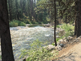
Part of the route wound its way through a river canyon, following the crystal-clear North Fork of the Boise River, which provided welcome opportunities to wash off the powdery dust that caked onto our sweaty faces. Many great places to camp and fish here, and few people.
According to our Idaho BDR information, we expected to cross a much narrower bridge at this location.
The corrugated road surface, dodgy traction, heat, and massive dust clouds took a toll on our patience and required us to spread out by several hundred meters to ensure we could each see where we were going. While waiting at one intersection, only Pete showed up behind me, and since we had been out of radio range, I was surprised to learn that Jeff had decided he'd had enough of the dirt riding and had bailed out to a highway, with the idea of rejoining us later.
As this was a remote area with limited to no cell reception, and Jeff didn't have a satellite device we could text to (Pete and I each had one), it wasn't clear how or where we'd reconnect. Pete and I decided to continue along the planned route, but our luck ran out a just couple hundred meters further when we reached a gate closing the road due to prior forest fire damage. Even if we'd decided to break the law and go around, our progress would've been stymied by considerable deadfall across the trail. No sense adding more hassles to our trip.
So, we turned around and tried to catch up to Jeff, who had a good head start by now and was on a much faster bike. Although I was at first disappointed to bail out onto pavement, the consolation prize was discovering a truly remarkable long section of twisty and steep asphalt, the Ponderosa Pine Scenic Route that wound its way into the hamlet of Lowman on the Payette River. After some faffing about to find Jeff in Lowman (we discovered that the gas station where we'd agreed to meet was out of business), we decided to push on to Warm Creek a few kilometers further, where there was also a gas station. This was where Jeff had stopped and waited for us, and we arrived just in time to buy a sandwich and fill up before they closed for the day.
After some discussing the day's events, it was clear that Jeff had had his fill of dirt on the trip. He was ready to slab it back to Canada. Considering that if we continued on the Idaho BDR we would be entering one of the roughest and most remote sections of the journey through the Bitterroot wilderness, it didn't make sense to add more stress to the journey. So, we all agreed to abandon the planned route and find another way home. For the rest of the day we followed the Ponderosa Pine Scenic Route up to the town of Stanley, where our luck changed again.
While gassing up after a dinner stop, we met Laura and her friend Dave who were topping up their KTM 690s. Laura was a dental hygienist and Dave was a NASA engineer. Both were from Oregon but had connections to Idaho where they liked to come regularly for the spectacular single-track riding. They had a plan and told us to grab some beer and follow them up Highway 75, which we did.
Soon we were soaking in the Sunbeam Hot Springs near Yankee Fork road, drinking beer into the night and adjusting rocks to achieve the perfect mix of hot and cold as the Salmon River flowed around us. Admittedly, we were all inspired by Laura's lifestyle, her incredible van camper conversion which somehow fit a bed and her 690 inside, and her riding adventure stories. Right then and there, Pete and Jeff decided to abandon their current lives and move to Oregon.
What a great way to end the day!
Laura and Dave recommended we continue our journey via the Yankee Fork Road along a historic stagecoach route through the site of a former gold rush. This is a route not to be missed and it helped quash any doubts about our earlier decision to abandon our original route. Thanks to both Laura and Dave for sharing these backcountry treasures with us. (Now married to one of her long-time riding buddies and on matching 790Rs, Laura doesn't seem to have slowed down one bit!)
Yankee Fork Road follows a watershed where extensive deposits of placer gold were found lying under the tumbled river stone. Along the side of the road for about 10km was a winding ribbon of this stone piled high. It was deposited by a most remarkable dredging machine which was painstakingly transported to the area in the 1940s. The dredge floated in the river, scooped out the stones some 30 feet down to the bedrock, separated out the gold in the fines, and discharged the stones in swathes behind it. The resulting piles turned the river into an environmental shamble in need of restoration to a natural and sustainable state. This work was underway, and we had to stop for work crews.
We finally reached the dredge itself, land-locked in a pool of stagnant water at the end of the tailings trail, where it ended its gold-digging journey decades ago. The dredge is open for tours led by locals with extensive knowledge of the history, some of whom lived in the camp when it was operating. Well worth a stop.
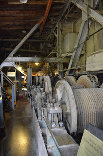
Inside was a maze of giant machinery that was hauled over the mountains to this remote location in pieces and assembled in situ. The entire machine was designed and built in something like 8 months.
Cable drums controlled the position of the barge and booms.
Electrical switchgear was primitive and probably not OSHA-compliant.
In the bowels was the machinery to separate out the rocks from the fines.
The fines were then sent to vibrating wash-tables, where the heavier gold particles were separated from silt and other debris, collected, and melted into ingots. Incredibly, the ingots themselves were simply mailed by USPS to a refinery in the east.
Engine porn: two 350HP Ingersoll Rand motors for producing electricity to drive the cable drums and other machinery.
Newspaper was pasted on the walls of this home to help keep out winter drafts. The following section was dated September 11, 1937 and contained a story about German-Americans in Salt Lake City denying ties to Nazis in Germany, who were of course a rising power at the time.
Our hot-spring soak was much more satisfying than this arrangement could possibly offer, although a tub must've been quite a luxury at the time.
This was in the gold assayers office.
Here were the ruins of the original General Custer stamp mill and namesake of the town, dating back to 1887. The original mining operations saw the ore-bearing rock blasted from the hills and crushed in the stamp mill to separate out the gold.
Now the road became a proper stagecoach trail, with remnants of the original buildings used to support the original operation still visible.
The original stagecoach route was a toll-road, brilliantly located in the only passable part of the region but nevertheless on the side of a very steep gully that posed many safety challenges to horse-drawn wagons on the downhill run.
The forests gave way to open country and the frontier town of Ellis.
It's a rough-and-tumble area with no discernible industry these days except for tourism. Lots of Harley riders passing through, probably en route north to the Sturgis rally.
Soon we were back to pavement and headed north along the Lewis and Clark Trail, where we planned to rendezvous with Jeff's in-laws (with whom we'd stayed in Eagle, CO weeks earlier), who were now camping in Idaho. A persistent, hot, dry wind like a blast furnace sapped our energy. We welcomed a stop to cool our boots in a river.
Jeff's in-laws were camped at a beautiful site on the Salmon River just west of the Lewis and Clark Trail. Here we rested for a bit before continuing north ourselves.


No comments:
Post a Comment